
Before putting shovel to earth on construction of a home here in Wilmington, North Carolina, you need to obtain certain documents that define and describe the land upon which you plan to build.
Among the most common of these documents are:
- Land surveys
- Topographical surveys
- Elevation certificates (sometimes referred to as elevation surveys or flood surveys)
Although each of these three document types serves a distinct purpose, they’re often confused with one another because each plays a role in outlining property details and dimensions. Understanding what each one represents — and why the differences matter — can help homeowners, builders, and buyers make better-informed decisions.
Whether you’re planning to build a new home, modify an existing one, or add a new structure to the land you own, having the right documentation in hand is key to properly complying with local building codes. In addition, any relevant homeowner association’s covenants and restrictions ensure you can get insurance for the new structure.
In this post, we unpack the unique functions of land surveys, topographical surveys, and elevation certificates, clarify when you might need one or the other, and help demystify this essential paperwork.
Similarities and Differences Between Land Surveys, Topographical Surveys, and Elevation Certificates
Land surveys, topographical surveys, and elevation certificates are all legal documents created by licensed professionals (typically surveyors) that rely on precise measurements and mapping. All three provide critical data about a property that can influence where and how buildings, including custom homes, are constructed. They also serve as official records for clarifying important characteristics of a piece of land. However, these three documents differ considerably.
A land survey is a detailed map that outlines the boundaries, dimensions, and physical features of a property. It depicts a bird’s eye view of a parcel, identifying property lines, structures, easements, and sometimes general topographical features. (An easement is a legal right others have to use a portion of your land for a specific purpose, such as gaining access to their property or access to utilities.) A land survey is essential in determining exactly where one piece of property ends and another begins. It ensures that improvements such as buildings, driveways, and fences are properly placed within the legal limits of the owner’s land.

A topographical survey is a three-dimensional map of the land that shows both natural and man-made features, such as hills, trees, drainage patterns, buildings, and elevation contours across the entire property. It’s typically used for engineering, design, and construction planning, helping architects, developers, or landscapers understand the lay of the land. While it includes elevation data, it’s not formatted or intended for flood insurance purposes as would be in an elevation certificate.

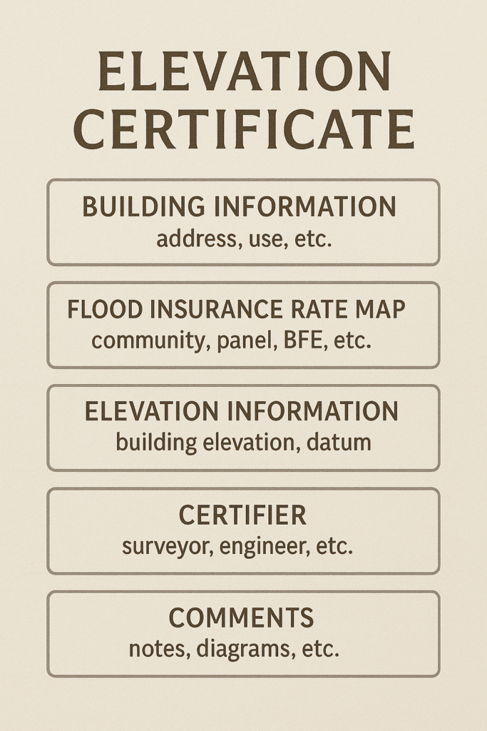
An elevation certificate is a specific document used primarily in relation to flood insurance and flood plain management. It provides information about a building’s elevation relative to the base flood elevation, which is determined by the United States Federal Emergency Management Agency (FEMA). Insurance companies use this data to assess flood risk and determine appropriate flood insurance rates. Unlike a land survey, an elevation certificate focuses specifically on the vertical aspect of a property and its structures, rather than on the periphery (borders) of a parcel of land.
While land surveys, topographical surveys, and elevation certificates are based on precise measurements and are often prepared by surveyors, they serve very different regulatory and financial purposes:
- A land survey is typically used by various stakeholders in real estate transactions to describe the location and dimensions of a parcel of land and resolve any property line disputes.
- A topographical survey is used primarily for engineering, design, and construction planning.
- An elevation certificate is used primarily to determine flood risk.
Here’s what you can typically expect from each type of survey:
Survey of Land:
- Identification of property boundaries and overall land area
- Placement of both man-made and natural features
- Documentation of easements and rights-of-way
Topographical Survey:
- Natural land features such as hills, valleys, and bodies of water
- Man-made structures such as buildings, roads, and utility lines
- Elevation contours to illustrate changes in terrain across the property
Elevation Certificate (Flood Survey):
- Lowest elevation point on the property
- Indication of any flood zones
- Building characteristics relevant to flood risk
Knowing When to Order a Survey or Certificate
Now that you can distinguish between land surveys, topographical surveys, and elevation certificates, you need to know when to order each type of documentation based on your needs. The following guidelines can help you decide:
Order a land survey when:
- You’re buying or selling property and need to verify boundaries
- You’re planning to build a structure, like a home, fence, or addition
- You need to resolve a property line dispute with a neighbor
- You’re subdividing land or adjusting lot lines
- A title company, lender, or local governing body (such as a municipality or homeowners association requires it for permits or legal documentation
Order a topographical survey when:
- You’re planning a construction or landscaping project and need to understand the lay of the land
- An engineer, architect, or planner needs detailed terrain info for design
- You’re evaluating drainage, grading, or site development issues
- You’re preparing for land development or large-scale remodeling
- A local governing body requires it as part of the permit or site plan review process
Order an elevation certificate when:
- You’re planning to purchase a parcel that might be prone to flooding
- Your property is in a FEMA-designated flood zone, and you need flood insurance
- Your insurance company requests it to determine flood risk and set premiums
- You’re trying to remove or reduce mandatory flood insurance requirements
- You’re planning construction in a flood zone and need to meet local or FEMA elevation requirements
- You’re applying for certain building permits in flood-prone areas
Obtaining the Survey or Certificate You Need
In most cases, a licensed land surveyor can provide all three types of documentation — a land survey, topographical survey, and elevation certificate. Land surveyors are trained and licensed to perform a variety of surveying tasks, including mapping property boundaries, measuring terrain elevations, and certifying flood elevations. You simply contact the surveyor to discuss your needs.
Your surveyor can help you determine the type of survey(s) or certificate(s) you’ll need. If the project requires specialized input — such as engineering analysis or architectural design — the surveyor might collaborate with other professionals, but they typically prepare the survey themselves.
Keep in mind that the documentation you need may already exist. If you purchased a parcel of land, chances are good that your closing papers include a land survey and possibly an elevation certificate. Also, these documents and others may have been filed with your county’s recorder and may be available online. Contact your county’s recorder to find out how to access the documents you need.
Note that although surveys and certificates don’t expire, local governing bodies may require that more recent surveys be submitted prior to starting any new construction projects. A local surveyor can tell you what you need.
Timing Matters: The right time to obtain a land survey and elevation certificate is before you buy a parcel of land. Otherwise, you run the risk of encountering some unpleasant surprises, such as finding out later that the parcel you purchased is too small for a single-family dwelling or that you can’t build on the land because it’s on a flood plain.
Choosing the Right Land Surveyor for Your Project
Selecting the best land surveyor for your particular situation is critical to your project’s success. You must take great care to ensure that the land surveyor you hire is licensed and experienced in performing the type of survey you need. We here at Wilmington Building Co. always recommend that you consider surveyors who have real-world experience in similar projects to yours who has performed surveys in the geographical area where you’re planning to build. You want someone who’s familiar with the area and its building rules and regulations.
To find the right land surveyor for your needs, take the following steps:
- Verify the surveyor’s licensing credentials.
- Read online reviews to gauge the satisfaction of previous clients.
- Ask for references and review their past work.
- Compare quotes and check for transparency in pricing.
Keep in mind that the lowest price doesn’t always mean the best value. When it comes to land surveying, accuracy and quality are paramount. Taking the time to thoroughly research and choose a trusted professional can help you steer clear of expensive errors and ensure your property is surveyed properly — giving you confidence and a strong starting point for your project.
Tips for Obtaining Land Surveys, Topographical Surveys, and Elevation Certificates
Following are some practical tips for obtaining the surveys you need for your custom home building project:
- Start with the end in mind. Figure out where you want to build and what you want to build and gather data from local governing bodies (including any homeowner or property owner association) about building codes and restrictions. Also consult with your insurance agent, who may be able to provide additional valuable insight and ensure that you have the coverage you need throughout the construction process. A local real estate agent may also be a valuable resource.
- Start early. The process for obtaining the required building permits can take months, and surveyors often book out weeks in advance, especially in busy seasons. Also, keep tabs on the process to ensure that it stays on track.
- Gather existing documentation. Check your property records for any previous surveys, deeds, site plans, or elevation certificates and check with your county recorder for any documents you’re missing. Existing documents can expedite the process and reduce the cost.
- Be clear about what you need. Explain the purpose and the scope of the survey to your surveyor — for example, to build a custom home, obtain an insurance quote, or buy a parcel of land. Clearly describing what you need up front ensures that you will get the documentation you need. In addition, the surveyor may be able to bundle services to reduce the cost.
- Get two or three quotes. Multiple quotes not only enable you to compare costs but also provide insight into what different surveyors recommend and how efficient, comprehensive, and responsive they are.
Precise land surveying plays a vital role in both effective property development and the resolution of boundary disputes. Here at Wilmington Building Co. — North Carolina’s premier coastal custom residential home builder— we can work closely with your surveyor, local governing bodies, and your insurance provider to ensure that you have all the necessary permits and insurance coverage before breaking ground.
Contact us as soon as you begin to formulate the vision of your custom home. That way, we can get begin laying the groundwork for bringing that vision to fruition.

Read the Comments +